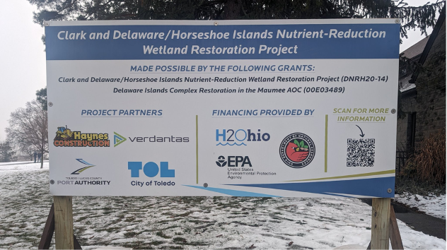
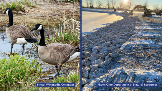
The beginning stages of construction for the Clark Island and Delaware/Horseshoe Islands restoration projects are underway! Construction of the first temporary construction causeway began on January 8, 2024. Construction groundbreaking celebration events were held on January 23 that included a media event with speakers followed by an open community reception. The community has demonstrated their […]
Read MoreNews
GLLA Work in the Maumee AOC
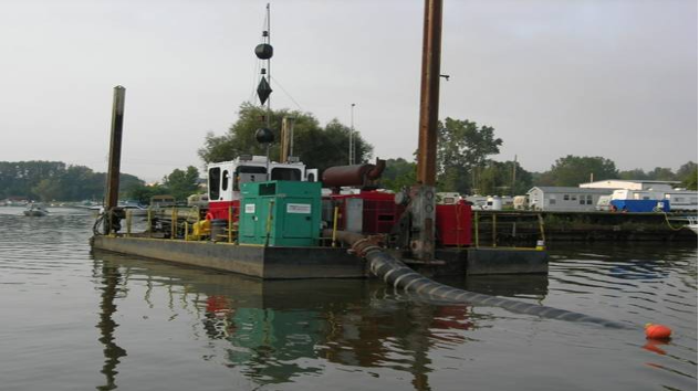
One of the fundamental pieces of improving Beneficial Use Impairments is locating and addressing significant chemical contamination in the sediments in the waterways of the Area of Concern (AOC). Those chemicals of concern in the sediments are often from historical industrial contamination of the past. In the Maumee AOC, there is ongoing Great Lakes Legacy […]
Read MoreProject Feature: Reducing the Impact of Chlorides
Every winter, rain and snow wash road salt into our ditches, streams, and rivers, which degrades water habitats by adding excess chlorides. Too much salt can be toxic for macroinvertebrates and fish. Experts agree that cutting down pollution at its sources will have a positive impact. Last year, a team of three MAAC collaborators began […]
Read More2023 Year In Review
Highlights, Management Action Project milestones, public involvement, outreach, and more.
Read MoreU.S. EPA Removes ‘Degradation of Aesthetics’ Impairment Designation from Maumee Area of Concern
(Via Ohio Lake Erie Commission) Conditions in the Maumee Area of Concern (AOC), one of the largest AOCs in the eight Great Lakes states, have vastly improved over the last 30 years, bringing the Maumee AOC one step closer to full restoration. These improved conditions are a result of reducing sources of oil, grease, and […]
Read MoreBUI 11 Removal Package Recommended for Approval
The Ohio Lake Erie Commission and Ohio EPA are recommending the removal of BUI 11, Degradation of Aesthetics, in the Maumee Area of Concern. At the May MAAC meeting, the Committee will be asked for concurrence with the recommendation before it moves to US EPA and the International Joint Commission for approval. A public comment […]
Read MoreProject Feature: Beach Improvements at Maumee Bay State Park
Maumee Bay State Park is a 1,336-acre public recreation area on the shores of Lake Erie. In 2021, work began on the park’s inland lake swimming beach to address BUI 10: Beach Closings. Persistent, elevated fecal indicator bacteria frequently cause this beach to have an advisory posted against it being used for recreation. Studies showed […]
Read MoreHill Ditch Restoration at Toledo NST Center
Hill Ditch Restoration at Toledo Natural Science Technology Center: This project focuses on creating instream and floodplain habitat for fish and benthos by stabilizing streambanks against erosion.
Read MoreMaumee River Islands Restoration Plans – Public Open House
The Toledo-Lucas County Port Authority, City of Toledo, and the Maumee AOC Advisory Committee (MAAC) are hosting a public open house to share new and refined draft designs and to seek input for these plans intended to help improve water quality and aquatic habitat while helping to restore and protect Clark Island and Delaware/Horseshoe Islands. […]
Read MoreProject Feature: Maumee Bay Wetland Restoration
Maumee Bay State Park is a 1,336-acre public recreation area on the shores of Lake Erie. In 2022, construction got underway and completed on a wildlife habitat management action project focused on enhancing the park’s wetlands. This project enhances about 130 acres of critical wildlife habitat around the shores of Lake Erie, an area that […]
Read MoreManagement Action Project Status Going Into 2023
Last year was a productive one for management action projects securing funding and reaching completion. For Wildlife Management Action Projects, 75% (15 of 20) were complete by the end of 2022, expanding habitat for key species in the Maumee AOC, such as the sandhill crane and wild turkeys. For Aquatic Management Action Projects, combining both […]
Read MoreNew Educational Materials Ready for Distribution
This year, the Maumee AOC’s facilitating organization, Partners for Clean Streams, had the opportunity to order hard copies of eight different management action project “rack cards,” as well as our updated Maumee AOC informational brochure. PCS would like to get these educational materials out into the community to keep residents informed about efforts to improve […]
Read More2022 Year In Review
Highlights: BUI 1, Restrictions on Fish and Wildlife Consumption, was removed! Management Action Projects: AquaMAPs – 32 of 35 projects are funded and several projects are underway. SedMAPs – 3 of 8 projects are fully funded, while the remaining 5 are partially funded. The 3 funded projects are completed as of November 2022. WildMAPs – […]
Read MoreMAAC Voting Member Applications Open for 2023-24
The MAAC is currently seeking applications for committee membership for 2023-24. Voting member positions are currently open for all categories, and the public citizen/academic/nonprofit field has a current vacancy. There is no limit to the number of non-voting (resource) member seats. Voting members serve for two-year terms, while non-voting members are appointed each year based […]
Read MoreClark Island and Delaware/Horseshoe Islands Restoration
The Toledo-Lucas County Port Authority, City of Toledo, and the Maumee AOC Advisory Committee (MAAC), with significant input from the Ohio Department of Natural Resources (ODNR) and Ohio Environmental Protection Agency (Ohio EPA), are leading planning efforts to help improve water quality and aquatic habitat while helping to restore and protect Clark Island and Delaware/Horseshoe […]
Read MoreTenmile Creek NPS-IS Available for Comment
Partners for Clean Streams has been updating watershed plans throughout the Maumee AOC. They need your input to help identify water resource projects in the Tenmile Creek area, such as eroding streambanks or spots in need of habitat restoration. The Tenmile Creek HUC-12 NPS-IS is ready for feedback and input. View and download the PDF […]
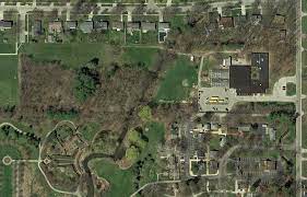
Read MoreProject Feature: Prairie Ditch Restoration at Secor Metropark
Metroparks Toledo is working to improve a section of Prairie Ditch within the expanded boundary of Secor Metropark, addressing BUI 6 (Degradation of Benthos), and BUI 14a (Loss of Fish Habitat). Secor Metropark includes over 600 acres of Oak Openings habitat in areas currently open to the public, containing walking trails, a visitors’ center, and […]
Read MoreBUI 1 Recommended for Removal
The Ohio Lake Erie Commission and Ohio EPA are recommending the removal of BUI 1, Restrictions on Fish and Wildlife Consumption, in the Maumee Area of Concern. The Ohio Lake Erie Commission and Ohio EPA made this recommendation because the conditions now meet restoration criteria that include fish and wildlife consumption in all waters of […]
Read MoreAquatic MAPs Funded and Underway
Of 35 Aquatic MAP (management action plan) projects, 13 are fully funded, 13 have funding allocated, and 3 have funding pending allocation. Funding will be requested for 3 more projects in late May and a few more have future anticipated funding requests in 2023. Aquatic MAP projects focus on BUIs directly associated with water quality: […]
Read MoreProject Feature: Wolf Creek Restoration at the Oregon Recreational Complex
The City of Oregon selected a stretch of Wolf Creek adjacent to the Oregon Recreational Complex for stream restoration, addressing BUI 6 (Degradation of Benthos), and BUI 14a (Loss of Fish Habitat.) This section of Wolf Creek is less than a mile from Pearson Metropark and only three miles from its mouth into Lake Erie. […]
Read More